Gallery
Wide mat, thin outer chamfer, opening inner mouth. The feel of a museum frame.
152 × 126 × 15 mm / ~102 g
Drag to rotate. Engine-generated 3D render, not a printed unit.
RENDER - NOT A PRINTED UNIT Rendered from the geometry the engine produced. It is not a photograph of a printed object. Physical prototype photos exist, but this exact render has no verified Engine2 sale-sample linkage.
Prototype / in development
A place's elevation data composed as colour layers with an integrated frame. This is an engine-generated design and has not been physically verified.
Not on sale. Physical prototype photos exist, but this exact product is not linked to a verified Engine2 sale sample. The form below records only an unverified expression of interest.
The same map, four different frame sections. The drawings in the lower row show the designed frame profile. That is where the depth comes from, not from thickness.
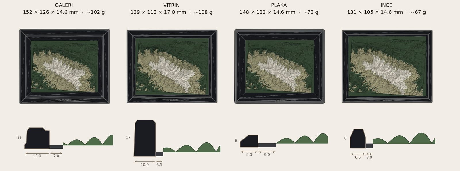
RENDER - NOT A PRINTED UNIT Frame direction study rendered from digital design geometry. Not a photograph or physical proof.
Wide mat, thin outer chamfer, opening inner mouth. The feel of a museum frame.
152 × 126 × 15 mm / ~102 g
High vertical wall, narrow mat. The relief stays deep, the shadow is strong.
139 × 113 × 17 mm / ~108 g
Frameless. Thick slab and a 45° chamfer all around. The most minimal direction.
148 × 122 × 15 mm / ~73 g
Very thin frame, narrow mat. Modern and light.
131 × 105 × 15 mm / ~67 g
A place is chosen and the engine turns real elevation data into printable geometry. Where a landmark needs manual cleanup, the report says so.
01
A coordinate box or a place name. The engine resolves an allowed elevation source, records it in the job manifest and fits it to the product scale.
02
Colour bands are derived from elevation thresholds. Each band is a separate body and gets its own filament in printing. Islands below the nozzle width are removed from the design so that what is printed and what is designed are the same.
03
Frame, mat and relief are designed to share one plate. The profile is intended to reduce support, but support use remains pending until this exact product is sliced with the real P2S profile.
The product is parametric. Everything below can change before printing.
Four slots. Base and frame share one colour; the remaining three bands go to the elevation steps of the map.
Wall mounting and magnetic assembly are in development, not part of the product yet.
Is assembly required?
No. Frame, margin and relief come out together in the same print. No glue, no screws, no interlocking parts.
Where does the data come from?
The elevation provider is resolved per order under the versioned source policy; geographic layers may come from OpenStreetMap contributors. The job manifest records the actual sources, licence class and required attribution.
Can I have the place I want?
Yes. The product is fully parametric. A coordinate box or a place name is enough. A fast preview typically lands in 20-90 seconds (measured range); the full print package takes a few minutes.
How does it look where the elevation range is small?
Flatter. That is the honest answer. Because the colour bands read elevation, mountainous regions stand out while coastal and plain regions come out calm. We review your region together beforehand.
How many colours are used?
Four. Because the base and the frame share one colour, no filament is spent on a surface nobody sees.
Nothing here is on sale. Leave an unverified expression of interest for a Regional physical prototype. It is not an order, reservation or payment.
REGIONAL / PHYSICAL PROTOTYPE / UNVERIFIED INTEREST